November 16, 2020
When it comes to national parks, the United States has its fair share of iconic ones. From the Grand Canyon to Yellowstone to Yosemite, the National Parks Service recognizes some of America’s most epic landscapes and ecosystems with its 62 national parks – and that’s not even counting the 350+ additional memorials, monuments, historic parks, and more that the NPS manages.
But I have to confess that I think Utah’s national parks really take the cake.
I’ve suggested before that Utah may be the most beautiful state in the U.S. It has everything from snowy mountains to arid desert, and the southern part of the state is just out of this world when it comes to scenery.
Which is probably why southern Utah is home to not one, not two, but FIVE different national parks. These parks – Zion, Bryce Canyon, Capitol Reef, Canyonlands, and Arches – are collectively known as “The Mighty 5.”
And, having visited all five of the “mighty” national parks in Utah, I have to say that the name is well-suited.
If you’re plotting out your American Southwest bucket list, you won’t want to skip southern Utah. And, to make it easier to decide which of the Mighty 5 parks you’ll want to visit, here’s what you need to know about visiting each one.
Travel guide to Utah national parks
1. Zion National Park
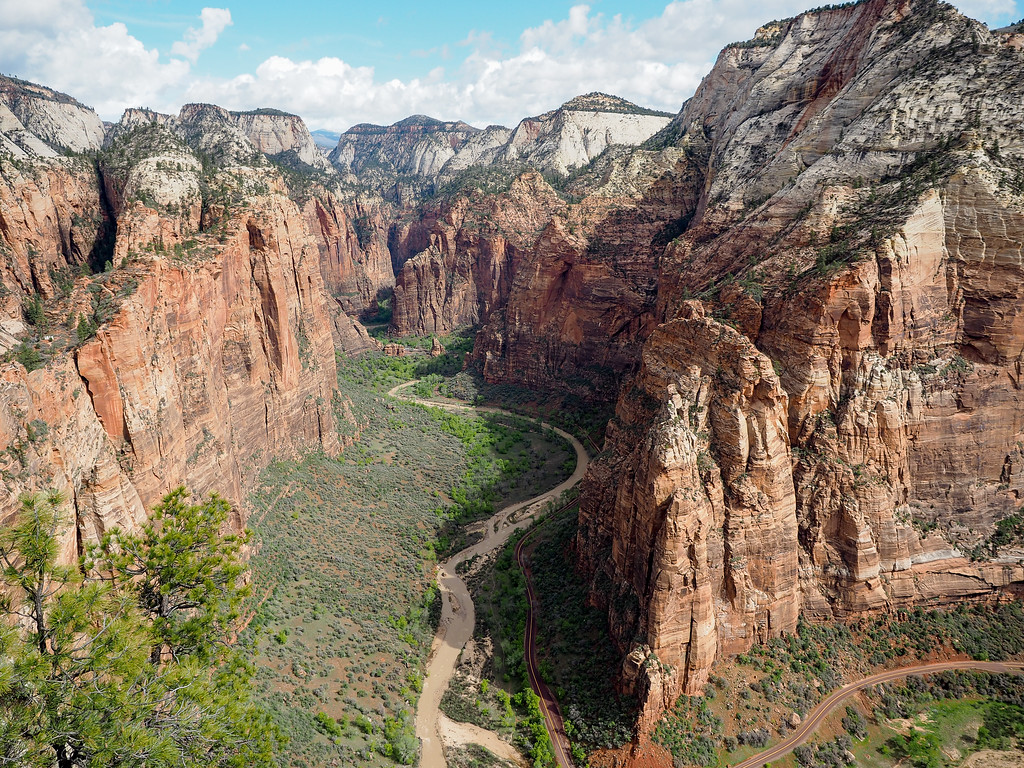
If you’re headed into southern Utah from Las Vegas (which is the route I took on my most recent Southwest road trip), Zion National Park will be the first park you’ll encounter. It became a national park in 1919, and many people cite it as their favorite national park in America. (It might be my new favorite, too!)
Entry: $35 per private vehicle; $20 per person if you walk or ride a bike/shuttle in
Getting around: You can drive the Mount Carmel Highway east from Zion to where it joins with US 89 any time of year (and I do definitely recommend this drive – it’s gorgeous!), but for seeing the rest of Zion Canyon, you have to use Zion’s free shuttle service to get around from March to October. You can park at the visitor’s center or in the nearby town of Springdale and use the shuttle to get to various trailheads and lookouts.
You can also reach the lesser-visited Kolob Canyons section of Zion from I-15 – it’s about a 45-minute drive from the main Zion Canyon.
What it’s known for: Zion is known for its towering mountains and red canyons, which were carved out by the Virgin River. It’s also known for popular (if difficult) hikes like Angels Landing and The Narrows.
2. Bryce Canyon National Park
The next park along the Utah national parks trail is Bryce Canyon, which can be reached via US 89 from Zion. Even though it also is filled with sandstone like Zion, the rock formations here are entirely different.
Getting around: During the summer months, a free shuttle takes visitors to all of Bryce’s popular viewpoints, but it’s not mandatory here like in Zion. You can self-drive through Bryce, too, and stop off at all the viewpoints – just beware of possible snow/ice, since Bryce is at a higher elevation.
What it’s known for: Bryce Canyon is known for its eroded sandstone towers known as hoodoos – the National Park Service says Bryce has the largest collection of hoodoos anywhere in the world! Stopping at all the viewpoints, therefore, is the most popular thing to do at Bryce Canyon (Sunset Point and Inspiration Point are my favorites).
If you have one day: If you only have one day at Bryce, be sure to make it to all the overlooks and viewpoints. Start all the way out at Rainbow Point, and then make your way back in: Inspiration Point, Natural Bridge, Sunset Point, etc. There’s an easy rim walk between Sunset Point and Sunrise Point that’s worth doing, too.
If you have more than one day: Get down inside the canyon if you have the time. The best hike to get up-close with the hoodoos is the Navajo Loop, which you can join up with either Wall Street (in the summer) or the Queen’s Garden trail (usually open year-round) for a complete hike. Or, if you want something longer and more strenuous, check out the Peek-A-Boo Loop.
3. Capitol Reef National Park
As far as national parks go, poor Capitol Reef is the park that gets overlooked the most often in Utah. If you head east from Bryce on UT-12 and UT-24, you’ll drive through a portion of Capitol Reef starting in the town of Torrey – but many people don’t
If Capitol Reef was in any other state, it probably would be really popular! But, in Utah, it’s usually the park people spend the least amount of time in. (And I’m guilty of it, too!)
Entry: $20 per private vehicle
Getting around: Driving yourself is the only way to get around Capitol Reef. You’ll see some of the park’s famous rock formations (for free) if you’re driving along UT-24, but to really see the park, you need to tackle the scenic drive within Capitol Reef’s fee area.
The Fluted Wall is along UT-24.
What it’s known for: Located in the heart of Utah’s red rock country, Capitol Reef is known for its cliffs and canyons in the Waterpocket Fold, which is essentially a wrinkle in the earth’s crust.
If you have one day: One day is enough to see the highlights of Capitol Reef, which include all the stops along the scenic drive. You’ll see cliffs, canyons, ancient petroglyphs, rippled rock, and more.
If you have more than one day: There’s some hiking to be done in Capitol Reef, including 15 day-hikes that range from short and easy to more strenuous. You can check out the hikes here. (Full disclosure: I didn’t do any hiking here, so I can’t recommend any specific trails.)
Where to stay: The small town of Fruita is at the center of Capitol Reef National Park, but the town of Torrey has more options when it comes to hotels. Check out the Capitol Reef Resort, which would be my top pick in the area. (Read reviews on TripAdvisor | Book here)
4. Canyonlands National Park
Next up is Canyonlands National Park, in southeastern Utah near the town of Moab. Canyonlands is actually broken into three different sections: Island in the Sky, The Needles, and The Maze, and has two major visitor centers (one at Island in the Sky, and one at The Needles).
Entry: $30 per private vehicle
Getting around: Self-driving is the best way to explore Canyonlands, especially if you want to visit more than one section of the park. (There’s roughly 60 miles of road between the Island in the Sky and Needles entrances, for example.)
What it’s known for: True to its name, Canyonlands is famous for its canyons and buttes that have been carved out by the Colorado River (the same river that carved out the Grand Canyon). It’s also known for its excellent mountain biking, with the 100-mile White Rim Road at Island in the Sky being the most popular trail.
If you have one day: The Island in the Sky district is the easiest to access – it’s less than an hour from Moab, and paved roads make it easy to reach all the viewpoints and trailheads. With one day, I would recommend visiting the famous Mesa Arch in the morning (it’s really popular at sunrise), going to the viewpoints at Grand View Point and the Green River Overlook, and then doing a short hike out to Upheaval Dome.
If you have more than one day: With an extra day, definitely drive out to The Needles, which is the second-most-accessible district in Canyonlands. The Needles is made more for hikers, with an extensive system of more than 60 miles of interconnecting trails.
5. Arches National Park
The last of the Mighty 5 national parks is Arches, also close to Moab in southeastern Utah. This park is very different from the other four on this list, and I also think is one of the most accessible since it’s only about 15 minutes from Moab and is filled with short, easy walks to see the famous arches.
Entry: $30 per private vehicle
Getting around: There are no shuttles at Arches, so you’ll need your own vehicle to explore the 18-mile-long scenic road through the park.
What it’s known for: The sandstone arches, of course! The park has more than 2,000 natural stone arches, along with pinnacles, cliffs, and balanced rocks. The rocks are also a brilliant orange-red, which looks great in photos.
If you have one day: In the morning, explore the scenic road and stop off at some of the viewpoints/shorter walks – Park Avenue, Balanced Rock, the Windows Section, and Double Arch would be my top picks. In the evening, hit the trail out to Delicate Arch, the most famous arch in the park and the symbol of the state of Utah. The hike is tough going up, so allow yourself 1-1.5 hours to reach the arch in time for sunset. At sunset, the sun paints Delicate Arch an incredible rusty orange color.
If you have more than one day: You can see all the major highlights of Arches in just one day, but if you have a second day, consider the Devils Garden Trail hike (7.2 miles total), or perhaps a ranger-guided hike of Fiery Furnace.
Where to stay: Arches is most easily accessed from Moab. I stayed in a cute Airbnb apartment, but there are also plenty of hotels and motels in town (along with lots of restaurants) to choose from. Check out the La Quinta Inn and Suites Moab, or the Holiday Inn Express Moab.
Know before you go
Before you head out to the Mighty 5 national parks in Utah, here are a few more tips for you:
- Bring water. You’ll always find water bottle filling stations at the visitor centers of each park, but you usually won’t find any along the hiking trails or even along the scenic drives. Zion and Bryce are at higher elevation, but still get warm in the summer. And Canyonlands and Arches get downright HOT, with daytime summer temperatures frequently reaching 100 degrees (F). MAKE SURE you have enough water with you, especially if you plan to do any longer hikes. I recommend getting a daypack with at a built-in reservoir rather than carrying just one water bottle.
- Wear good shoes. If you’re just doing scenic drives, your flip flops will be fine. But if you decide to tackle any of the longer hikes, you NEED proper footwear. And I don’t just mean your favorite pair of hot pink Sketchers – you need hiking boots. I saw people with Converse and Sketchers on the Angel’s Landing trail, and they were slipping and sliding all over the slickrock (sandstone). I love my Merrell Moab hiking boots (they’re even NAMED after a spot in Utah!) – I wore them for every hike on this trip.
- Be prepared for every kind of weather. Many of Utah’s national parks have their own little micro-climates – meaning you can never fully predict what the weather will be like. Wear layers that you can shed (or put back on), and always pack a raincoat in your daypack. (I love the Columbia Arcadia II jacket, as it’s very waterproof.)
- Beware the sun. Getting sunburnt is the worst – avoid it by applying (and re-applying) sunscreen, and wearing a hat when possible.
- Get a National Parks Pass. If you do the math, visiting the Mighty 5 all in one trip will set you back more than $150. This is where an annual pass for the national parks comes in handy. The “America the Beautiful” pass costs $80 and is good for 12 months – meaning it will save you quite a bit of money if you plan to visit a bunch of national parks.
Share This Article